Our Process
Working with NC Remote Sensing is designed to be clear, efficient, and professional from start to finish. Our process follows a structured workflow that ensures accurate data collection, open communication, and fast delivery whether you’re managing a small site or a complex project.
From initial scoping to final handoff, we focus on aligning with your specifications, maintaining FAA and industry compliance, and providing the deliverables your team needs to move forward with confidence.
1 – Scope & Quote
You provide the project boundary, estimated acreage, and any notes on terrain or vegetation. We will return a flat-rate quote and proposed flight window.
2 – Coordination
We will ask for your coordinate system and vertical datum, any control checkpoints you can provide, and a heads-up on features such as dense vegetation, steep slopes, or bodies of water.
3 – Flight Operations
Our FAA certified pilots fly each mission with full RTK integration. We adhere to all FAA regulations and coordinate with airspace authorities to arrange authorizations and waivers as needed.
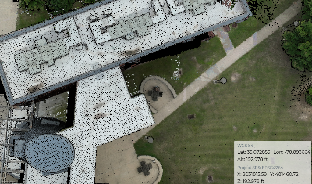
4 – Processing & QA
Post-flight, we process the point cloud, review it for completeness and accuracy, and generate a visual preview for review.
5 – Deliverables
NCRS provides clients with raw LiDAR point cloud files in industry-standard LAS format for validation and integration by our licensed partners. A browser-based preview link, supporting metadata, and an accuracy and compliance report are also supplied.
Need Support With Your Own Drone Program?
NCRS helps organizations plan, launch, and sustain drone operations with training, equipment support, and practical field guidance.
Program Setup & Launch
- Program planning and SOP basics (roles, workflows, safety, documentation)
- Mission planning support (mapping, inspection, public safety, facilities, etc.)
- Operations readiness checklists (preflight, maintenance, data handling)
Equipment Acquisition & Setup
- Platform selection guidance (airframe, payloads, batteries, RTK, accessories)
- Procurement support and configuration
- Initial setup: firmware, accounts, settings, remote ID, storage, workflows
Training, Skill Building, & Support
- FAA Part 107 prep and test readiness coaching
- Hands-on flight skills (manual control, emergency procedures, confidence building)
- Mission training: mapping and modeling, inspection workflows, data capture basics
- Post-launch refreshers, troubleshooting, and scaling support
Why Choose Us

You Are In Control
You define the project scope, standards, and delivery schedule. We execute field operations precisely to your requirements, without altering your process or interfering with your client relationship.

No Capital Investment
Eliminate the need to invest in costly drone platforms, sensors, maintenance, software licenses, certifications, and specialized training. We deliver high-quality data on demand and without the overhead.

Verifiable Data
All data is collected and documented in strict alignment with our acquisition workflow and quality assurance procedures. ASPRS standards are embedded throughout every stage of the process.

No Regulatory Hassle
Our team operates under full FAA certification, manages all airspace authorizations, and adheres to local and federal regulations reducing your risk and administrative burden.

Your Clients, Your Relationships
Your firm remains the sole point of contact for your client. We alongside licensed professionals to enable delivery of high-quality data under their brand and ensure they retain full control of project outcomes.
What You Receive
.LAS Point Cloud
NCRS provides secure access to the project’s .LAS file, working alongside licensed surveyors and engineers as they validate and incorporate the data into their workflows.

Quality & Accuracy Reporting
Comprehensive accuracy, compliance, and quality reports are delivered to your specifications and aligned with your ground control data.
Web-Based Preview
We provide a web-based preview link that allows you to view coverage and point density in your browser and easily share it with clients and partners via email – no software install is required.

Our Team
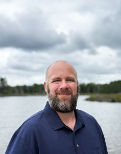
Ben Poulin
Ben is a seasoned drone operations expert and educator. He led the launch of the UAS Operations Training Center at Beaufort County Community College and served as its Director. In addition to his work with NCRS he currently operates Propwash Drone Solutions, supporting organizations in developing and managing UAS programs with a focus on training, compliance, and real-world operations. Ben holds multiple certifications in UAS operations and photogrammetry.
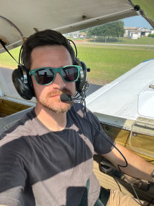
Paul Rossi
Paul Rossi is a U.S. Army veteran and private pilot with over 16 years of aviation and UAS experience. In addition to his work with NCRS he serves as Director of Development & Safety at Causey Aviation Unmanned and co-founded Nine Ten Drones, a leading UAS training and sales provider in North Carolina. With advanced degrees from Embry-Riddle, Paul helps shape safe, scalable drone programs across commercial, public safety, and educational sectors.
Contact
Have questions or ready to get started? Reach out today, we’re here to help.
NCRS is a proud sustaining member sponsor of the North Carolina Society of Surveyors